Last Updated on October 2, 2022 5:52 pm
5:20am – roads around the area are snow covered and slick according to incoming social media reports, and reports from Watauga County Communications dispatch office.
5:20am – this incoming early morning report via social media “421 mtn from wilkes is ok until parkway bridge then gets wet and in some spots slush until laurel springs church then one lane into boone some spots white just take your time and be careful.”
18 degrees in Boone with wind chill of 2 below zero at 5:26am
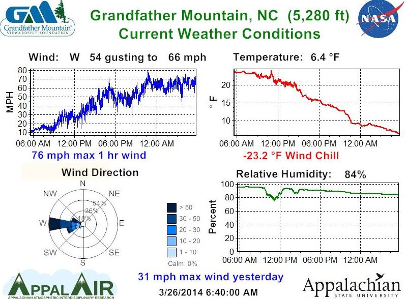
Peak wind gust so far of 48mph in Boone at 5:15am
Special Weather Statement from NWS from 3/26/2014 5:45 AM to 8:30 AM EDT for Ashe, Watauga : SNOW DECREASING BUT ROADS STILL SLICK IN SPOTS. 1.usa.gov/1l3re2E
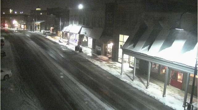
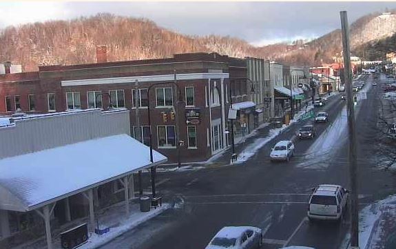
The view in downtown Boone at 6am
6:35am – per incoming reports roads in the county are snow covered and slick, with blowing snow also a problem this morning. Not hearing of any major accidents or traffic delays yet. Early morning travel is not advised if possible.
wind chill of -25 on Grandfather Mtn this morning
321 Boone to Blowing Rock wet roads mainly. Patchy snow per incoming report at 6:55am.
6:50am incoming report “421 is snow covered and slick. Saw one car off the road with SHP on site. Bamboo to Wilson Ridge snow covered. Wilson Ridge is in good shape and passable by all vehicles. Deerfield slick around the S-bends to Bamboo. Bamboo to Boone International is snow covered”.
7am – incoming reports indicate that main roads are fully or partially snow covered, secondary roads are fully covered and gravel roads are fully covered. Winds continue to gust over 40mph with wind chills below zero.
downtown Boone at 7:56am
Limited construction operations today on 321 in Blowing Rock due to weather. Call 828-964-3260 for project information.
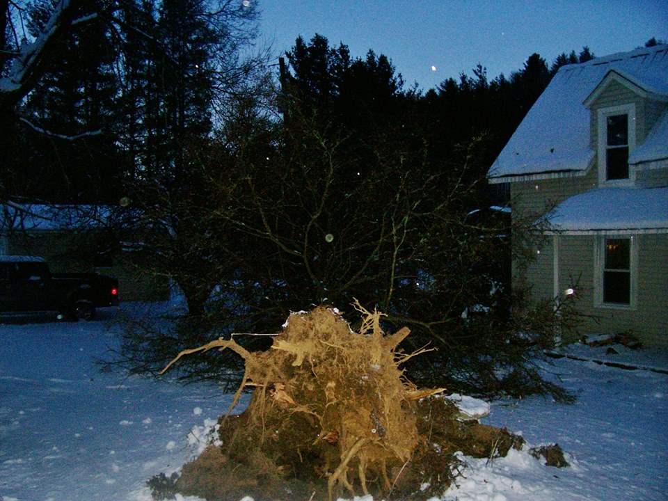
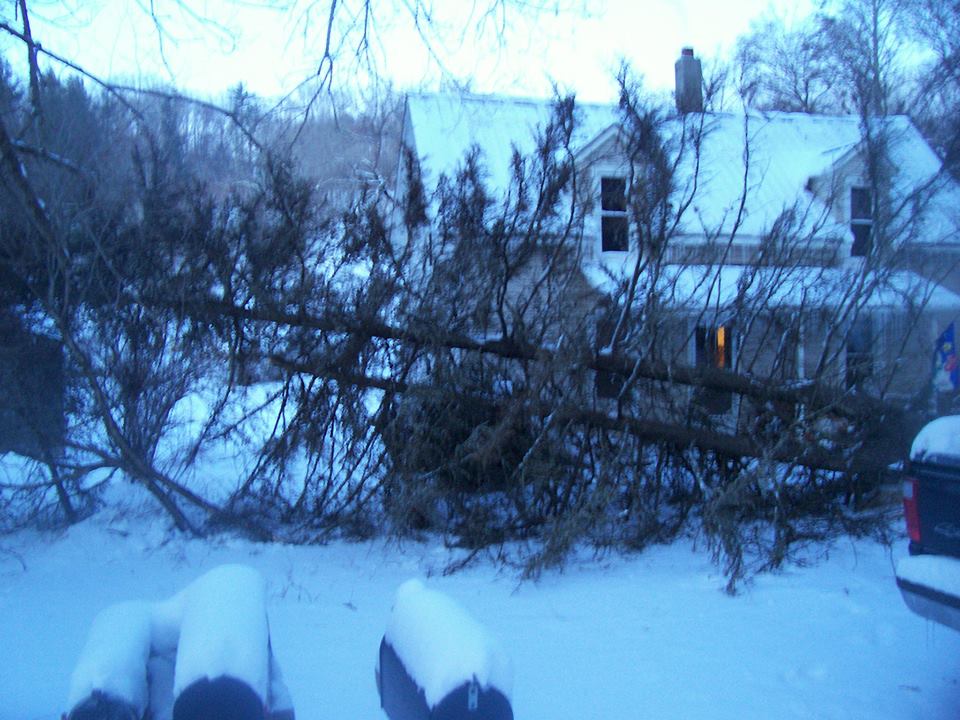
Robin Price passes along these photos of a tree that fell over in her yard around 5:45am near New Market Center. She adds that “It went down at just the right angle to miss our vehicles and house”. Price estimates the tree to be around 50 feet tall.
9:30am – have not received any reports of travel issues in the last half hour which usually is a good sign that things are running much smoother than earlier this morning. Be advised that main roads are in good shape per the last reports, secondary & gravel roads fully covered. Winds continue to gust over 40mph with wind chills in the single digits.
From National Weather Service:
1119 AM EDT WED MAR 26 2014
THE FOLLOWING ARE UNOFFICIAL OBSERVATIONS TAKEN FOR THE SNOW THAT
FELL YESTERDAY AND THE ADDITIONAL SNOW THAT FELL THIS MORNING THAT
HAS BEEN AFFECTING OUR REGION. APPRECIATION IS EXTENDED TO THOSE WHO
PROVIDED REPORTS. THIS SUMMARY IS ALSO AVAILABLE ON OUR HOME PAGE AT
WEATHER.GOV/BLACKSBURG.
********************STORM TOTAL SNOWFALL********************
LOCATION STORM TOTAL TIME/DATE COMMENTS
SNOWFALL OF
/INCHES/ MEASUREMENT
NORTH CAROLINA
…ALLEGHANY COUNTY…
3 ENE GLADE VALLEY 5.0 800 AM 3/26 COCORAHS
ROARING GAP 3.8 1001 AM 3/25 PUBLIC
…ASHE COUNTY…
6 NW LANSING 5.5 700 AM 3/26 COCORAHS
1 ESE WEST JEFFERSON 3.7 700 AM 3/26 COCORAHS
3 ESE JEFFERSON 2.0 800 AM 3/26 COCORAHS
…ROCKINGHAM COUNTY…
1 W LAWSONVILLE 3.0 1227 PM 3/25 TRAINED SPOTTER
STONEVILLE 1.0 915 AM 3/25 BROADCAST MEDIA
EDEN 1.0 950 AM 3/25 FIRE DEPT/RESCUE
…STOKES COUNTY…
FRANCISCO 2.0 1010 AM 3/25 EMERGENCY MNGR
4 NNW DANBURY 1.4 700 AM 3/25 COCORAHS
DANBURY 1.0 700 AM 3/26 CO-OP OBSERVER
…SURRY COUNTY…
4 W MOUNT AIRY 5.5 700 AM 3/26 COCORAHS
MOUNT AIRY 3.4 700 AM 3/26 CO-OP OBSERVER
2 E LOW GAP 2.8 1120 AM 3/25 TRAINED SPOTTER
SILOAM 2.5 900 AM 3/25 PUBLIC
2 S LOW GAP 2.1 820 AM 3/25 TRAINED SPOTTER
ELKIN 1.3 1034 AM 3/25 TRAINED SPOTTER
…WATAUGA COUNTY…
1 SE BEECH MOUNTAIN 12.2 600 AM 3/26 COCORAHS
3 ENE BLOWING ROCK 7.0 700 AM 3/26 COCORAHS
1 WSW FOSCOE 7.0 650 AM 3/26 COCORAHS
4 NE BLOWING ROCK 5.8 700 AM 3/26 COCORAHS
5 E BOONE 5.2 900 AM 3/26 COCORAHS
BOONE 2.7 700 AM 3/26 CO-OP OBSERVER
VALLE CRUCIS 2.5 835 AM 3/25 TRAINED SPOTTER
ZIONVILLE 2.0 925 AM 3/25 PUBLIC
…WILKES COUNTY…
3 E HAYS 3.0 1035 AM 3/25 PUBLIC
5 WNW PURLEAR 1.1 900 AM 3/25 COCORAHS
…YADKIN COUNTY…
YADKINVILLE 0.2 155 PM 3/25 911 CALL CENTER