
Last Updated on January 30, 2013 9:02 am
Wednesday Jan 30
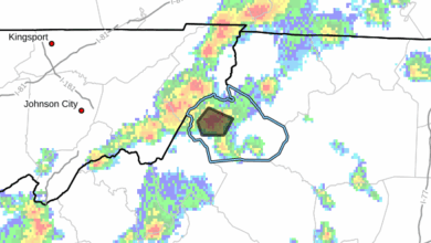
Tornado Watch for Johnson County TN until 1pm today. High Wind Warning and Flash Flood Watch for Watauga & Ashe today
NWS graphic showing the watches and warnings for today 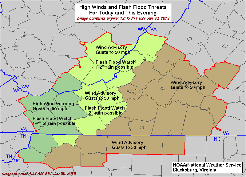
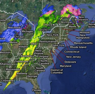
Here's a look at just how large this storm system is
From Brad Panovich this morning – TRACKING SEVERE STORMS: The cold front and line of strong to severe storms is moving east through eastern Tennessee this morning. It arrives in the mountains 11am-1pm. the foothills 1pm-3pm then the Piedmont and Charlotte areas 4-7pm. I expect a tornado watch will likely be issued before the line arrives. Expect the wind to really pick up as we go through the day. Stay alert of possible warnings as well.
9:04am – tree blocking the road at Aho Road & Mosley Mountain Road, DOT is on the scene.
NWS Video Update
9:30am – winds have once again picked up with gusts over 20mph
A friendly reminder on the definitions of Watch, Warning and Advisories. Graphic from NWS Morristown

9:37am per DOT – Currently there are no ops on 321 in Blowing Rock due to weather.
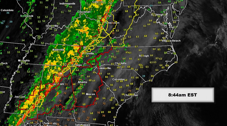
10am – the storms are getting closer, leading edge in Morristown TN
10:40am – updated tornado risk map from Brad Panovich

Damaging Wind Chances for today. Graphic: Brad Panovich

11am – leading edge of this weather system is in Johnson City extending toward Mountain City.
Radar view at 11:05am

Flood Watch for Johnson County TN until 10pm tonight
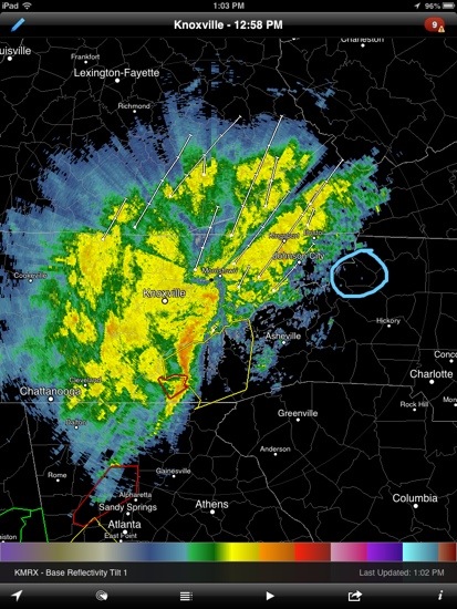
What a mess. Radar view at 12:04pm

NWS Storm Predication Center tornado probability for today

NWS Storm Predication Center wind probability for today

12:53PM – according to WXII TV 421 has been completely shut down in Winston-Salem after a tanker truck overturned just after noon today. Photo from WXII facebook page

1pm radar shot
The areas in yellow are under a Tornado Watch. Brown is High Wind Warning. graphic from US National Weather Service Greenville-Spartanburg SC

Avery County is now under a Tornado Watch until 8pm
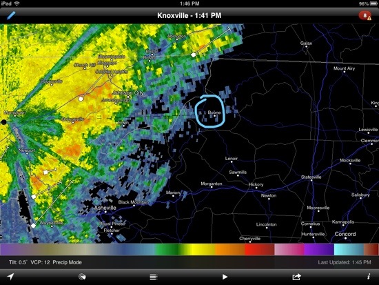
1:41pm radar shot
Johnson County TN is NO longer under a Tornado Watch. High Wind Warning and Flood Watch is still in effect – 1:52pm
1:55pm – Tornado Watch for Avery until 8pm. High Wind Warning & Flood Watches for Watauga, Ashe, Johnson County TN.
Severe Thunderstorm Warning to 3:15 for Avery & Watauga County
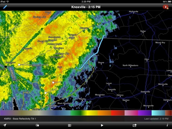
The blue line is roughly the stateline at 2:15pm
2:28pm – spurts of heavy rain in the western and southern ends of Watauga
2:30pm – NWS is advising of 40mph gusts, prolonged heavy rain which could cause flooding in a statement just issued. That SPC is in effect until 3:30pm
Severe Thunderstorm Warning for Watauga and Avery is now CANCELLED – 2:49pm
severe storms chances the rest of the evening from Brad Panovich

3:18pm – Flooding still a real threat for all of the High Country the rest of today and tonight.
Wilkes County now under a Flash Flood Watch until midnight
3:25pm – High Wind Warning has been extended to 4pm Thursday for Ashe, Watauga and Grayson County Va
3:30pm –
Watauga – High Wind Warning until 4pm Thursday, Flash Flood Watch until midnight
Ashe – Severe Thunderstorm Warning until 4pm, High Wind Warning until 4pm Thursday, Flash Flood Watch until midnight
Avery – High Wind Warning until 4pm Thursday, Tornado Watch until 8pm
Wilkes – Flash Flood Watch until midnight, Wind Advisory until 4pm Thursday
3:45pm – Severe Thunderstorm Watch to 10:00 PM for Wilkes County, Ashe County, Watauga.
3:45pm – from our facebook page “Visibility on 321 from blowing rock down off of mtns less than 100 ft”
3:53pm – first report of the mall parking lot (321 side) starting to flood, has not been blocked off yet.
THE NATIONAL WEATHER SERVICE IN BLACKSBURG HAS ISSUED A
* URBAN AND SMALL STREAM FLOOD ADVISORY FOR…
ASHE COUNTY IN NORTHWEST NORTH CAROLINA…
ALLEGHANY COUNTY IN NORTHWEST NORTH CAROLINA…
WATAUGA COUNTY IN NORTHWEST NORTH CAROLINA…
SOUTHWESTERN CITY OF GALAX IN SOUTHWEST VIRGINIA…
GRAYSON COUNTY IN SOUTHWEST VIRGINIA…
EXTREME SOUTHWESTERN CARROLL COUNTY IN SOUTHWEST VIRGINIA…
* UNTIL 930 PM EST
* AT 350 PM EST…DOPPLER RADAR INDICATED HEAVY RAIN THAT WILL CAUSE
URBAN AND SMALL STREAM FLOODING IN THE ADVISORY AREA. UP TO ONE
INCH OF RAIN HAS FALLEN IN THE PAST HOUR ON SATURATED GROUND…AND
AN ADDITIONAL INCH IS LIKELY THROUGH THE REMAINDER OF THE
AFTERNOON.
* SOME LOCATIONS THAT WILL EXPERIENCE MINOR FLOODING INCLUDE
BOONE…TODD…ENNICE…SPARTA…JEFFERSON…INDEPENDENCE…
FRIES…SUGAR GROVE…TROUTDALE…MOUTH OF WILSON…ASHLAND…
LANSING…SANDS…LOVILL…RUTHERWOOD…SILVERSTONE…MEAT CAMP…
REESE…WHITEHEAD…STRATFORD…TWIN OAKS…SCOTTVILLE…OTHELLO…
WAGONER…COMERS ROCK…WEST JEFFERSON…BALDWIN…TROUT…
FLEETWOOD AND PINEY CREEK.
4:05pm – car stranded in mall parking lot (321 side), scanner reports no one is in it. Safe bet they'll block that entrance off.
4:10pm – mall parking lot 321 side is blocked off due to flooding
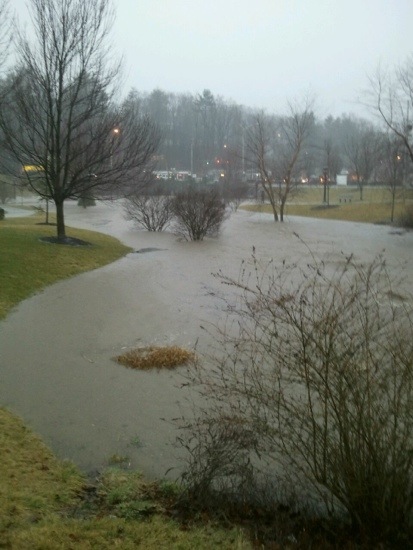
Kraut Creek On ASU Campus 4:14pm. Photo:Kara Harmon


Flash Flood Warning to 8:15 PM EST for Avery, Johnson County TN, Wilkes, Ashe, Watauga
4:26pm from facebook page “On Bamboo Road near the quarry, there is a driveway that has washed out onto the road. Lots of muddy water around it and a lot of rocks on the road.”
Flash Flood Warnings are delivered through Wireless Emergency Alerts that activate some cell phones. More information can be found at: http://www.nws.noaa.gov/com/weatherreadynation/wea.html
4:30pm – pre facebook page reports here are some areas flooding “Tyson Park…. In town” “Elk Creek at Watauga/Ashe Co. line” “Intersection of 321 and 105 at Wendy's is a mess. Drive carefully if you must”
4:33pm – report that bridge at Dewitt Barnett Road in Valle Crucis is underwater
More facebook reports “194 is messy as well as Castle Ford rd”
4:39pm – power outages Watauga 33, Alleghany 22
4:48pm – getting a report that Wendy’s intersection is covered in water, as deep as some cars are tall
4:50pm per Boone PD twitter- RT @boonepolice: Water is starting to stand in the roadway here @ the PD to the Big Light in the North bound lane of 321.Use caution or avoid the area.
Durham park on campus flooded. Photo BillieJo Greene
5pm – there are so many reports of flooding coming in it's hard to keep track. Use EXTREME CAUTION driving. Don't dive in standing water, TURN AROUND DON'T DROWN.
new waterfall near Wood circle. Photo: Laura Sharpe

5pm – Deerfield by the golf course from Wilson’s Ridge to parking deck at Medical Center is SHUT DOWN
Mall parking lot – Billie Taylor

5:12pm – report of a mud slide in the corner before Tweetsie, a stump is in the road. DOT is making their way to the scene per scanner.
5:20pm – there are several roads around Boone that are being closed. Due to the volume we may not have a chance to list them all. Use caution.
Wendy’s intersection. Photo: Joshua Patrick Mcconkey

5:25pm – Farthing Street and Chesnutt Street being closed to traffic per scanner
5:28pm – Small mudslide on 105 coming into Boone near the rock crusher per scanner
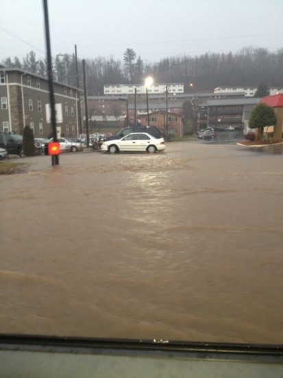
321 at Hardee's
5;45pm Due to heavy rain and flash flooding in the area, all ASU classes and events on campus are canceled immediately
Rare Flash Flood Emergency issued for Watauga County. Never drive into a water covered road per NWS
6:08pm – 105 ext at 321 at the big light is shut down per scanner
6:12pm – Per ASU Cars parked in the Raley and Duncan parking lots should be moved as soon as possible. Info: http://t.co/bjMSYcBv
6:20pm – roads across the area, especially in Boone, continue to be closed off due to the water. If you are somewhere safe you are advised to stay there until the rain ends little later tonight.
6:30pm – another swift water rescue about to take place, this one in Boone
6:37pm – getting report of mudslide at Tweetsie, swift water rescue taking place in Bamboo, lot of roads in the area continue to be closed due to the water.
6:39pm – report from fb page “Excessive mud,rocks and debris in roadway on 321 South just north of Blackberry Condos and at Rocky Knob Rd and at the beginning of the 4 lanes. Drive slow and be careful as it is easy to lose the roadway!”
Boone [Watauga Co, NC] fire dept/rescue reports FLASH FLOOD at 06:35 PM ESTbit.ly/UEdVKk?RNK
Winklers Creek closed at bridge
6:48pm – per NWS – Rain is not expected to end until around midnight, so additional flooding is expected
6:50pm Fire, EMS, county officials are working on getting shelter(s) open in the county per scanner
6:55pm- bottom apartments in Bavarian Village are being evacuated
Fairway Drive being shut down – 7:03pm
7:06pm per ASU - "If students, faculty or staff are unable to safely travel home because of the flood conditions, please report to the Plemmons Student Union Information desk by no later than 9:00PM and you will be provided safe shelter. If no one needs shelter at the Student Union, then it will close at 9:00 PM on Wednesday, January 30th."
7:15pm – Zeb St blocked Greenway Rd is flooded behind Kmart
7:27pm – getting unconfirmed reports that some buildings on ASU are flooding.
Per Boone Police these roads are closed:
Greenway Road
Meadowview Drive
Leola Street
Fairway Drive
Faculty Street
Watauga Village Drive
Pride Drive
Bamboo Road @ airport
Deerfield Rd at Golf Course
Dewitt Barnett Rd low water bridge along the Watauga River
7:39pm – more evacuations are about to take place in Boone at Bavarian Village
7:44pm per ASU – If students, faculty or staff are unable to safely travel home because of the flood conditions, please report to the Plemmons Student Union Information desk by no later than 9:00 p.m. and you will be provided safe shelter. If no one needs shelter at the Student Union, then it will close at 9:00 p.m. on Wednesday, January 30th.
Ashe County Schools will be closed for students and staff on Thursday, January 31. It will be an annual leave day for staff.
7:54pm – one emergency shelter will be set up at the Hospitality House
8:04pm – Bradford Trailor Park completely evacuated, Hospitality House open for a shelter
8:11pm – per scanner these building at Bavarian Village were evacuated, the rest are safe : 500-900 buildings
8:25pm – REMINDER Watauga-Flash Flood Warning until 12:30am Thursday, High Wind Warning until 4pm, Flash Flood Watch until 4am, Flood Advisory until 11pm tonight.
8:36pm – the GOOD news it appears a majority of the rain is out of our area. The BAD news is that temps tonight forecast in 20s with snow and 50-60mph gusts. Wind chills in single digits.
8:42pm – officials with the Red Cross are opening up a shelter at the Blowing Rock Conference Center
Walmart and Bank of America Area about 7pm Wednesday. Photos by Jak Kesselring


9:11pm – per scanner Meadowview Drive is back open
9:28pm – Leola Street is just about to be re-open
9:52am – a large hole has developed on 321 in front of University Hall Drive per scanner. Boone PD on the scene until DOT can arrive.
10pm – the Red Cross shelter at Blowing Rock Conference Center is closing. If anyone needs shelter go to the Hospitality House 338 Brook Hollow Rd
10:15pm – From Boone PD –
Flood waters have receded in some areas allowing roads to re-open. However, the following roads remain closed:
Fairway Drive
Bamboo Road @ airport
Deerfield Rd @ Golf Course
Dewitt Barnett Rd @ low water bridge along the Watauga River
A propane leak in the Boone Docks Street area has been controlled.
The threat of flash flooding remains with a flash flood warning in effect until 01/31/2013 @ 12:30 AM. All citizens are reminded to remain vigilant and motorist are advised to avoid driving into water covering roadways.
11pm – ending updates for the night due to the early morning snow/ice issues projected. Stay safe in the overnight and updates resume early Thursday morning.