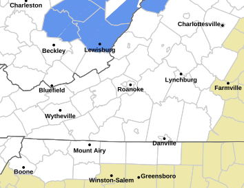
Weather Forecast/Radar
*Added February 2013 Interactive Doppler Radar for mobile and non mobile devices*


Click on specific county radar for larger view
Watauga County
Ashe County
Avery County
Radar provided by
Forecast provided by- National Weather Service :
Tonight: Mostly cloudy. Showers with isolated thunderstorms this evening…then a chance of showers after midnight. Some thunderstorms may produce heavy rainfall this evening. Lows in the upper 50s. Northwest winds around 10 mph this evening… Becoming light and variable. Chance of rain 90 percent.
Wednesday: Partly sunny with a 20 percent chance of showers. Highs in the lower 70s. Northwest winds around 10 mph.
Wednesday Night: Mostly cloudy. A slight chance of showers in the evening. Lows in the mid 50s. Light and variable winds. Chance of rain 20 percent.
Thursday: Partly sunny. A chance of showers and thunderstorms in the afternoon. Highs in the mid 70s. Light and variable winds. Chance of rain 30 percent.
Thursday Night: Mostly cloudy. A chance of showers and thunderstorms…mainly in the evening. Lows in the mid 50s. Light and variable winds. Chance of rain 30 percent.
Friday: Partly sunny. A chance of showers and thunderstorms in the afternoon. Highs in the mid 70s. Chance of rain 30 percent.
Friday Night: Partly cloudy with a chance of showers and thunderstorms in the evening…then mostly clear after midnight. Lows in the upper 50s. Chance of rain 30 percent.
Saturday And Saturday Night: Partly cloudy. Highs in the mid 70s. Lows in the upper 50s.
Sunday Through Monday: Partly cloudy with a chance of showers and thunderstorms. Highs in the upper 70s. Lows in the upper 50s. Chance of rain 30 percent.
Monday Night: Mostly cloudy. A chance of showers and thunderstorms in the evening. Lows in the lower 60s. Chance of rain 30 percent.


