


Last Updated on May 6, 2013 3:20 am
Flash Flood Warning until 8:45 AM for Watauga, Flood Warning to 9:15 for Wilkes, Flood Warning to 6:30 AM for Avery, Flood Warning to 7:15 AM for Ashe
3:30am power outages – Watauga 473, Ashe 109, Wilkes 1 in Blue Ridge EMC member area
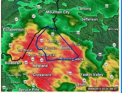
Radar at 3:24am – http://wataugaroads.com/radar/
3:52am – per Boone Police – Deerfield Road near Blairmont is closed Avoid the area & use an alternate route don't drive through any standing water or blocked roadways.
4:52am power outages – Watauga 487, Ashe 18 in Blue Ridge EMC member area
4:56am – per Boone PD – Boone Mall is now flooding. Remember "Turn around don't drown".
5am – via facebook – “Tree down on Vanderpool road right when you turn on towards cove creek elementary .Blocking road completely”
Watauga County Schools are on a 2 hour delay for Monday May 6. Any additional changes or updates will be made by 7am http://wataugaroads.com/closingscancellations/
4 NE Beech Mountain [Watauga Co, NC] county official reports FLOOD at 05:00 AM EDT – http://mesonet.agron.iastate.edu/lsr/#RNK/201305060900/201305060900/0100
5:23am – Portions of Watauga River Road remain closed this morning due to flooding of the Watauga River according to NWS
5:34am – 5 W Blowing Rock [Watauga Co, NC] mesonet reports HEAVY RAIN of M5.37 INCH at 05:00 AM EDT bit.ly/11aswTH?RNK
Radar shot at 5:28am – http://wataugaroads.com/radar/

5:37am – power outages – Watauga 487, Ashe 57 in Blue Ridge EMC member area
5:45am – If you are traveling 221 between Avery and McDowell counties per McDowell Weather facebook page – *LANDSLIDE ON 221 NORTH AT THE TOP OF THE MOUNTAIN; MUDSLIDE BLOCKING 1 LANE OF TRAVEL ON 226A ABOVE TURKEY COVE*
5:50am – Portions of Charlie Thompson road are closed due to flooding
5:53am – from Blue Ridge Electric facebook page – Heavy rain for days is causing trees outside the right of way to fall onto power lines in some areas. Please be cautious as you're out today and stay far away from downed power lines as they can still be energized! Linemen have been working this morning in Watauga and Ashe counties to restore outages, including: Old Watauga River Rd where 318 members are affected and 2 power poles are being replaced. Another downed tree has affected 84 members on George's Gap Rd. In Ashe, 51 members off Deep Ford Rd. are affected Please report all outages to our PowerLine: 1-800-448-2383
5:54am – Boone Fire responding to a car that is washing away near the Moose Lodge. Remember – Turn Around Don't Drown!
6:06am – getting report that power just went out around the Boone Mall area, the parking lot on 321 side continues to flood.
Event extended (time). Areal Flood Warning from 5/6/2013 6:09 AM to 12:15 PM EDT for Ashe County. 1.usa.gov/ZKO0U6
6:11am – power outages – Watauga 487, Ashe 63 in Blue Ridge EMC member area
6:13am – per facebook report “rock slide just South of Green Park Inn. Law enforcement is there and it's passable”
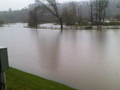
New River is breaking its banks. Photo: Joel Greaves

6:19am – from Blue Ridge Electric – Linemen are replacing 2 broken poles near Old Watauga River Rd. Nearly 500 affected in Watauga Cnty due to several trees on power lines.
6:22am – DOT reporting NC 184, East of Banner Elk in Avery is closed
6:28am – Via Jennifer Spink - Condos at Kellwood by airport. Water up to porch

New event. Areal Flood Warning from 5/6/2013 6:29 AM to 10:30 AM EDT for Avery County.1.usa.gov/ZKPo9c
6:36am – New River Heights road closed, river is across the road per scanner
Power is back on around Boone Mall area – 6:37am
6:41am – facebook reports – “baseball diamonds on State Farm are flooded. Took Fairway road to get to Bamboo this morning – lots of water running down the road. Airport area of Bamboo is flooded and will be for some time.”
Niley Cook Road at 6:42am. Photo: Rich Brown

Condo now surrounded by water at Kellwood per Jennifer Spink

portion of Roby Greene Road closed per DOT – 6:47am
6:48am – from Boone PD – Boone Mall Entrance on 321 side is closed. Water is starting to stand in the roadway on 321 especially in the area of the Mall and Staples.
6:50am – power outages – Watauga 424, Ashe 12 in Blue Ridge EMC member area
Behind the national guard in Boone @ 6:20am. Photo: Matt Head

Both baseball fields on State Farm Road under water – 6:55am
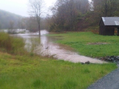
Valley Creek in Seven Devils. Photo: Dan Hugo


7am – Charlie Hollar Road closed per DOT
Event extended (time). Areal Flood Warning from 5/6/2013 7:09 AM to 1:15 PM EDT for Wilkes County, Ashe County. 1.usa.gov/ZKS1Ij
Photo: Blairmont and Deerfield at Moose lodge http://iruntrails.tumblr.com/post/49767430162/blairmont-and-deerfield-at-moose-lodge
Meat Camp Road –
7:16am – http://wataugaroads.com/radar/

Water to the right of this camera shot in Valle Crucis – http://wataugaroads.com/cams/

7:32am – power outages – Watauga 332, Ashe 12, Caldwell 1 in Blue Ridge EMC member area
7:40am – Watauga River Road and Valle Crucis. Photo: Bald Guy Brew

7:50am – power outages – Watauga 60, Ashe 12, Caldwell 1 in Blue Ridge EMC member area
All schools except Valle Crucis will open with a two hour delay on Monday, May 6th due to flooding on a number of roads. Valle Crucis School is closed for today, Monday, May 6th. The afterschool program at Valle Crucis will also be closed today.
New event. Areal Flood Warning from 5/6/2013 8:13 AM to 8:00 PM EDT for Watauga County.1.usa.gov/ZKWnz2
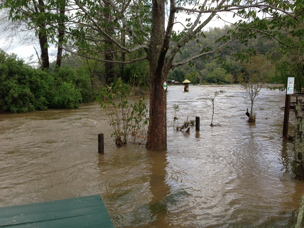
Water levels on the Watauga River

A waterfall on Broadstone Road in Valle Crucis where there normally is not one

Brookshire Park. Photo:Barry Houck – 8:32am

1 SE Beech Mountain [Watauga Co, NC] cocorahs reports HEAVY RAIN of M5.81 INCH at 06:00 AM EDT bit.ly/11aFJMh?RNK
8:53am – power outages – Watauga 14, Ashe 12, Caldwell 2 in Blue Ridge EMC member area
This lake was a golf course. Photo: Kristen Mann

184 in Avery County is back open per DOT at 9am
Brookshire Park. Photo: Karisa Aparicio
Roads impacted by high water today – http://tims.ncdot.gov/tims/RegionSummary.aspx?co=95

9:25am – according to Watauga Schools website – "All schools will be closed today, Monday, May 6th due to flooding on area roads and to the forecast that water levels may continue to rise during the remainder of the day. The afterschool program and the holiday/snow day program at Hardin Park are also closed today. "
Video update from NWS
9:48am – scanner report of a mudslide on 321 near Trash Can Falls in Cove Creek/Sugar Grove blocking one lane.
CoCoRahs map of 24 hour rainfall reports from the Boone, NC area. ow.ly/i/233xf
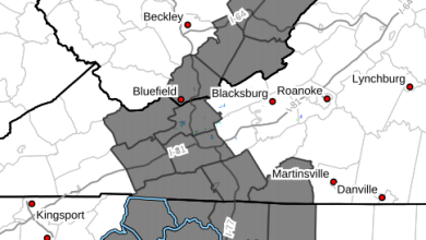
NATIONAL WEATHER SERVICE BLACKSBURG VA
856 AM EDT MON MAY  6 2013

...PRECIPITATION TOTALS...

THE FOLLOWING IS A LIST OF UNOFFICIAL PRECIPITATION TOTALS FOR A 24
HOUR PERIOD ENDING AT  8 AM MONDAY. THESE REPORTS ARE FROM A
COMBINATION OF SOURCES INCLUDING COOP OBSERVERS...COCORAHS...IFLOWS GAGES...AND
ASOS AND HAVE NOT BEEN QUALITY CONTROLLED.


NORTH CAROLINA


...ALLEGHANY COUNTY...

    1.95   SPARTA COCORAHS
    1.82   LITTLE R/SPARTA IFLOWS

...ASHE COUNTY...

    3.80   TODD COCORAHS
    3.41   BUFFALO CREEK IFLOWS
    2.92   NF NEW/ASHLAND IFLOWS
    2.86   JEFFERSON 2 E COOP
    2.82   NF NEW R. / CLIFTON IFLOWS
    2.79   LAUREL SPRINGS RAWS
    2.46   TRANSOU COOP

...STOKES COUNTY...

    0.54   KING COOP
    0.46   DANBURY COCORAHS
    0.30   DAN RIVER AT PINE HALL

...SURRY COUNTY...

    1.09   RAVEN KNOB RAWS
    0.43   ARARAT COCORAHS
    0.38   ARARAT R. AT ARARAT
    0.35   MOUNT AIRY COCORAHS
    0.30   MOUNT AIRY COOP

...WATAUGA COUNTY...

    5.89   MF NEW RIVER IFLOWS SG
    5.81   BEECH MOUNTAIN COCORAHS
    5.65   BLOWING ROCK COCORAHS
    5.58   SANDY FLATS IFLOWS
    5.08   BOONE COCORAHS
    4.90   BOONE 1 SE COOP
    4.70   TRIPLETT RG DCP
    4.65   PARKWAY SCHOOL IFLOWS
    4.11   BOONE RG (TVA)
    3.25   SHAWNEEHAW FD IFLOWS
    2.15   WATAUGA R/FOSCOE IFLOWS
    1.07   BANNER ELK COCORAHS

...WILKES COUNTY...

    3.78   RENDEZVOUS MTN RAWS SITE
    3.59   ELK CREEK AT ELKVILLE DCP
    3.08   WILBAR RG DCP
    2.51   MILLERS CREEK COCORAHS
    2.40   W KERR SCOTT RESV COOP/DCP
    2.32   NORTH WILKESBORO COOP
    2.25   NORTH WILKESBORO COCORAHS
    1.83   ROARING RIVER DCP

...YADKIN COUNTY...

    0.50   YADKINVILLE 6 E COOP
10:16am – power outages – Watauga 14
321 in Sugar Grove Photos:Harriett Edmisten


The kindergarten orientation scheduled for today at Parkway has been changed to this Wednesday, May 8th. Parents and children that would have gone today will have the same appointment times on Wednesday.
The kindergarten orientation scheduled at Parkway for tomorrow, Tuesday, May 7th, will take place as scheduled.
Dewitt Barnett Road bridge in Valle Crucis. Photos: Kenneth Reece


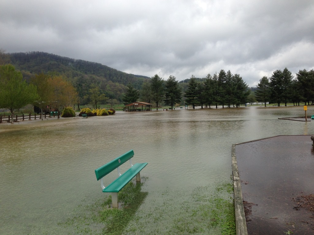
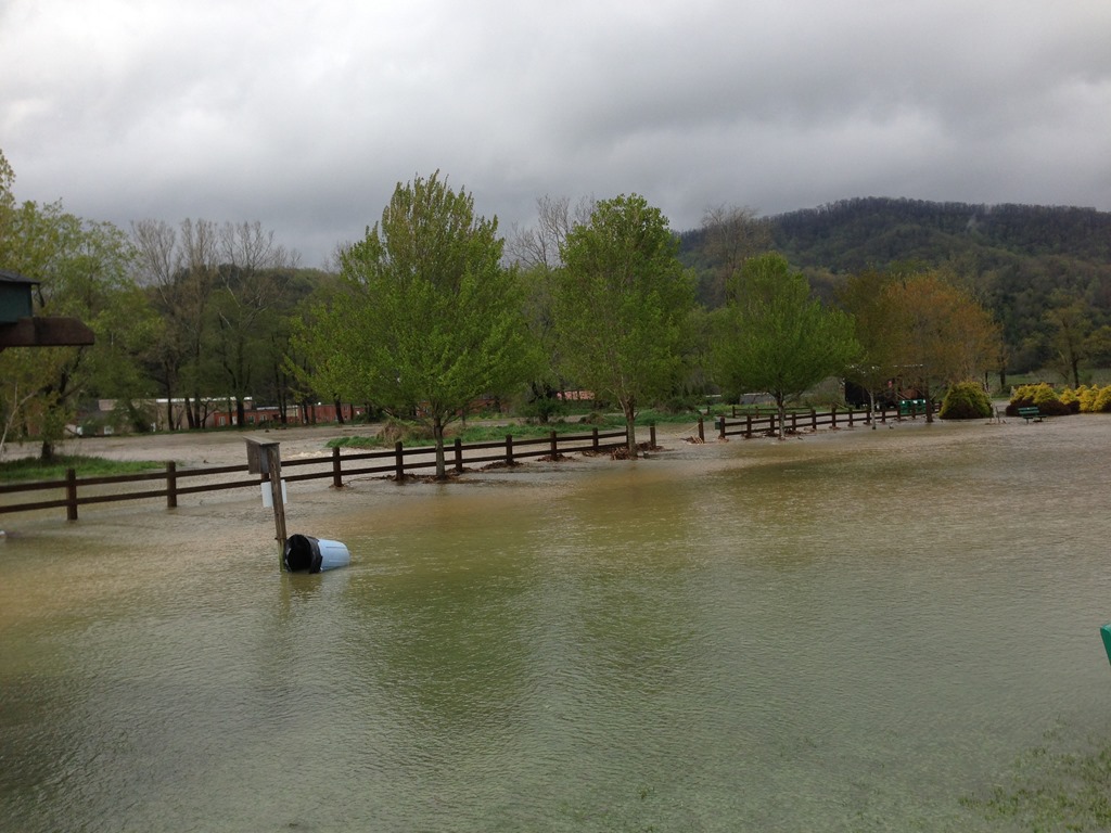
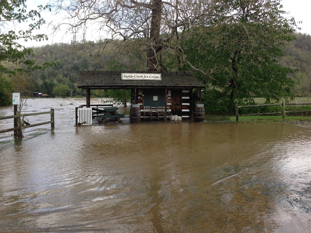
Valle Crucis Park. Photos: Kenneth Reece


Dewitt Barnett Road bridge flooding. Video: Kenneth Reece
Valle Crucis Park flooding. Video: Kenneth Reece
1:22pm – getting a report of pea size hail around Seven Devils/Grandfather area
Valle Crucis flooding. Video: Kenneth Reece
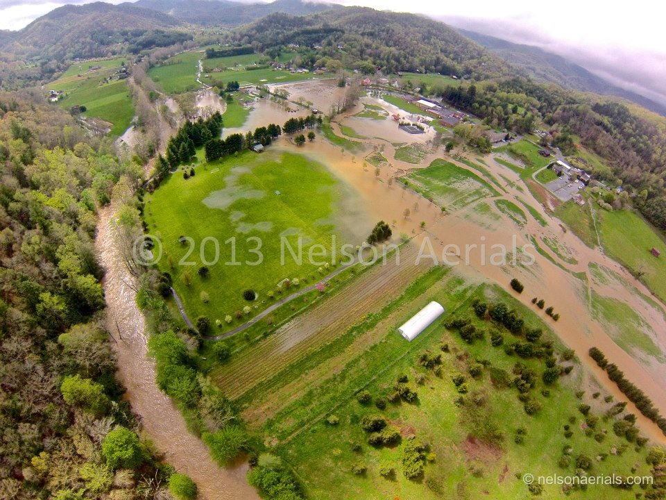
High above the flood waters in Valle Crucis. Photos by Nelson Aerials

4:30pm – According to Sherriff's office “following roads still closed: Roby Greene, Barnett, Hubert Thomas, Guy Ford, Watauga River. Airport Rd may open at 5PM”
5:22pm – Deerfield Road is now open between the Moose Lodge and Wilson's Ridge.


