


Hurricane Helene

Hurricane Helene
Overview
Hurricane Helene became the deadliest hurricane to strike mainland United States since Hurricane Katrina in 2005, and the most costly and deadly hurricane in North Carolina history. According to the National Hurricane Center's Tropical Cyclone Report, Helene caused at least 250 fatalities in the United States (176 direct, 74 indirect) and $78.7 billion in damage, making it the 7th costliest U.S. hurricane on record.
For the High Country region, Helene delivered Boone's most devastating flood event since the Great Flood of August 13, 1940, and likely its worst disaster since the 1916 flood. The storm shattered all-time precipitation records in all three High Country counties—records that had stood for 20 to 131 years.
The storm arrived after three days of relentless rainfall that began on September 25, 2024. A stalled cold front combined with a predecessor rain event saturated the ground before Helene's tropical moisture swept through the mountains on September 27, creating a near worst-case scenario for catastrophic flooding.
Storm Timeline
A rare EF-1 tornado touched down near Blowing Rock around 7 PM – the first tornado in Watauga County since 1998. Heavy rain began falling from a stalled cold front. Afternoon thunderstorms dropped 1.61 inches of rain in some areas.
Hurricane Helene formed in the Gulf of Mexico and rapidly intensified to Category 4 strength with 140 mph winds. Governor Roy Cooper declared a state of emergency for North Carolina. The Blue Ridge Parkway closed. App State canceled Saturday's football game against Liberty. Tropical moisture began feeding into the stalled front over Western North Carolina. By midnight, an additional 10.60 inches of rain had fallen in some High Country locations.
Helene made landfall near Perry, Florida at 11:10 PM Thursday night as a Category 4 hurricane. The massive storm tracked north through Georgia and entered North Carolina as a post-tropical storm with winds still at tropical storm strength (75 mph). The heaviest rainfall occurred Friday morning as Helene's remnants moved directly over Western North Carolina.
Wind gusts exceeded 40 mph in valleys and reached 101 mph near Banner Elk.
The North Carolina Department of Transportation issued an unprecedented statement that “all roads in western NC should be considered closed.” Flash flood emergencies and extreme rainfall warnings were issued across Watauga County throughout the day.
Downtown Boone resembled a river, with King Street and Depot Street completely inundated. Appalachian State University sustained major flooding damage to campus facilities along Boone Creek and River Street. The university closed through October 5, with classes and athletic events canceled through October 15. The Walmart on Highway 321 flooded and remained closed for several months. More than 200 people were rescued from flood waters across Watauga County.
Rainfall Records
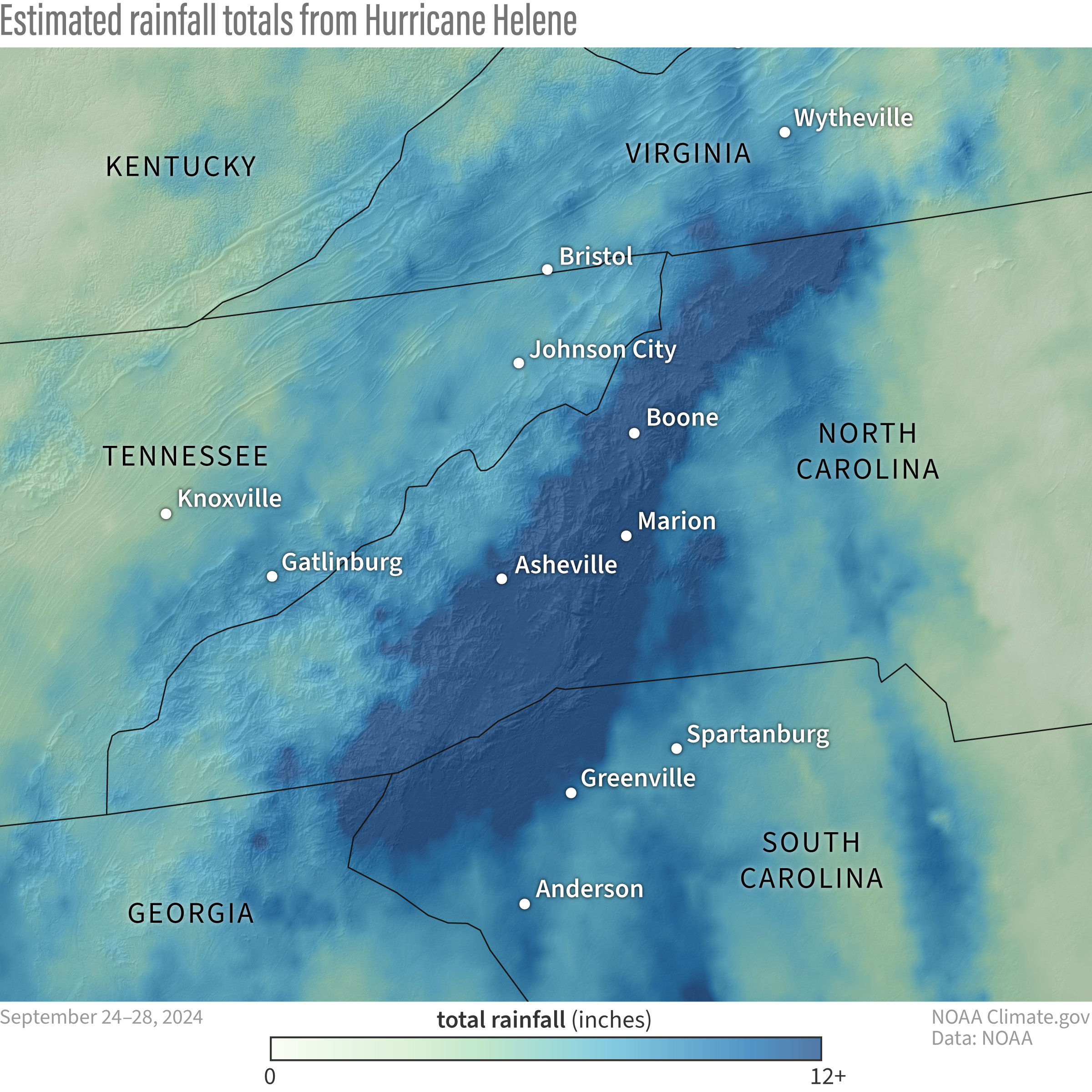
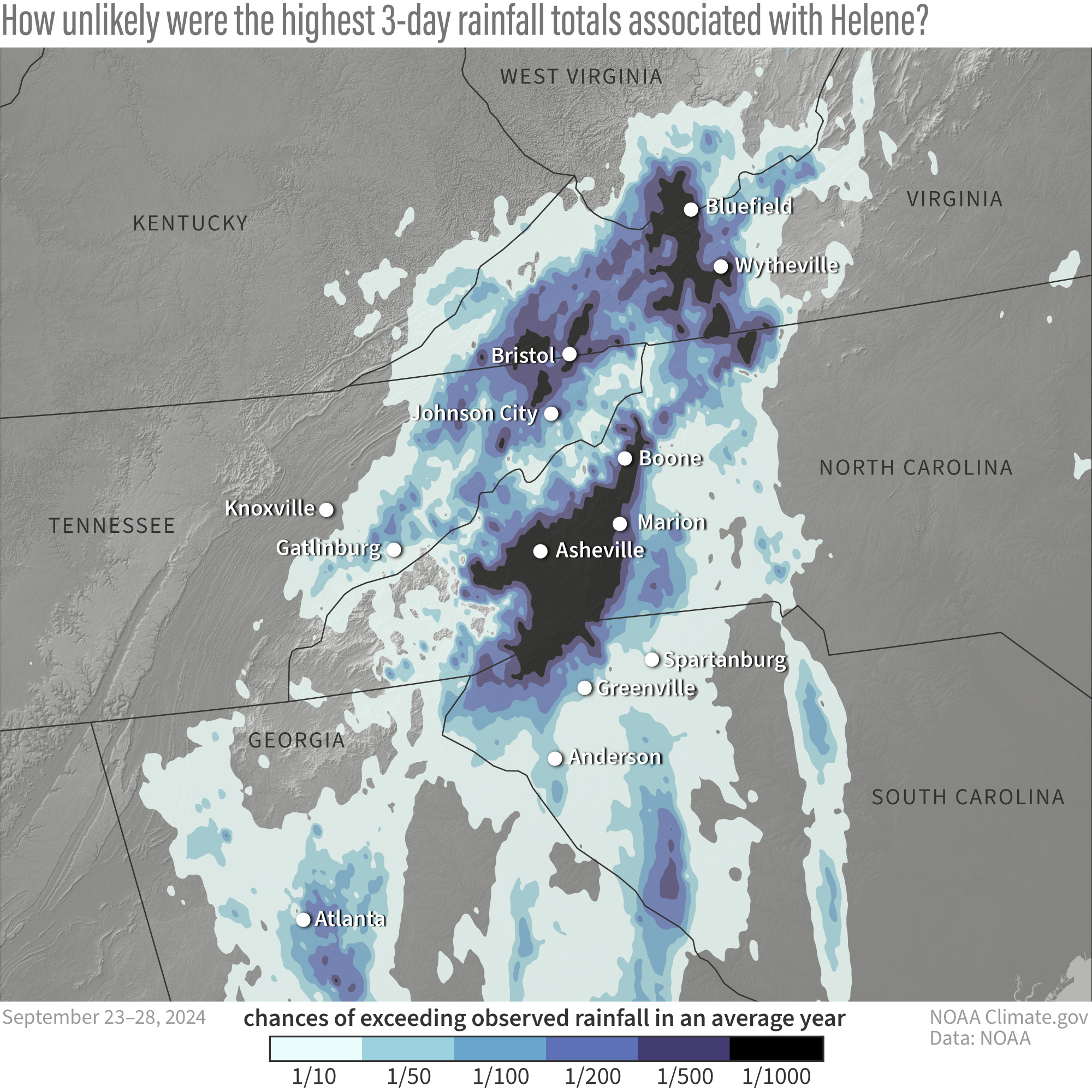
The three-day period from September 25-27, 2024, produced historic rainfall totals across the High Country. The combination of tropical moisture from Helene and orographic lift from the mountains created an atmospheric river that dumped unprecedented amounts of rainfall, shattering records that had stood for decades.
🌀 Hurricane Helene Shattered All Records
Regional Rainfall Map
Once-in-1,000-Year Rainfall
High Country Rainfall Totals by County
The National Hurricane Center's official Tropical Cyclone Report documented rainfall totals that shattered all-time records across all three High Country counties:
Watauga County
| Location | Rainfall Total | Source |
|---|---|---|
| Seven Devils 1 E | 21.47 inches | CoCoRaHS – County record |
| Foscoe | 21.60 inches | NHC Report |
| Boone (3.8 mi ENE) | 20.12 inches | CoCoRaHS |
| Blowing Rock (2.2 mi NE) | 16.91 inches | CoCoRaHS |
| Boone (official COOP) | 16.67 inches | NWS Cooperative Observer |
Previous Watauga County record: 9.50 inches (Blowing Rock, September 14, 1893) – a record that stood for 131 years.
Avery County
| Location | Rainfall Total | Source |
|---|---|---|
| Banner Elk | 22.85 inches | NHC Report – County record |
| Banner Elk (0.7 mi W) | 14.85 inches | CoCoRaHS |
Previous Avery County record: 11.57 inches (Grandfather Mountain, September 8, 2004) – a record that stood for 20 years.
Ashe County
| Location | Rainfall Total | Source |
|---|---|---|
| 9 mi SSE West Jefferson | 17.08 inches | NHC Report – County record |
| Sparta (COOP) | 17.29 inches | NC Climate Office (3-day) |
| West Jefferson (1.5 mi W) | 10.95 inches | CoCoRaHS |
| West Jefferson (1.4 mi SE) | 9.08 inches | CoCoRaHS |
Previous Ashe County record: 13.08 inches (Idlewild, August 14, 1940) – a record that stood for 84 years.
Regional Context
| Location | Rainfall Total | Notes |
|---|---|---|
| Busick, NC (Yancey County) | 30.78 – 31.33 inches | Highest total in North Carolina |
| Connestee Falls (Transylvania) | 29.98 inches | Second-highest in state |
| Mount Mitchell ECONet | 24.41 inches | Adjacent to High Country |
| 7 mi SW Spruce Pine (Mitchell) | 23.31 inches | NHC Report |
| Grandfather Mountain RAWS | 15.42 inches | Remote Automated Weather Station |
📊 Historical Context
Boone's September 2024: 23.01 inches – This made September 2024 the 2nd-wettest September on record in Boone, representing nearly 40% of the city's annual average rainfall of 59 inches.
Asheville Regional Airport: 17.90 inches in September 2024 – The wettest month on record dating back to 1869, surpassing all previous records in 155 years of weather observations.
River Flooding
Watauga River at Sugar Grove
The Watauga River reached a crest of 29.5 feet above flood stage (flood stage is 6 feet), tying the historic record set during the Great Flood of August 13, 1940. This represents a rise of 23.5 feet above normal flood stage, inundating vast areas of bottomland and threatening structures that had stood for decades.
Other Rivers
The French Broad River in Fletcher crested 10 feet higher than its previous peak from Hurricane Frances in 2004. In Asheville, the French Broad River peaked at 24.8 feet, exceeding the 108-year-old record of 23.1 feet set during the legendary 1916 flood. The Swannanoa River at Biltmore reached 26.1 feet—the worst flood since North Carolina statehood. At least 63 stream and river gauges across the region exceeded their record flood levels during Helene.
Wind Impacts
Hurricane Helene brought life-threatening wind gusts much farther inland than typical tropical systems, due to its fast forward motion and enormous size. The storm's wind field extended 500 miles across, significantly larger than Hurricane Katrina's 350-mile wind field.
Recorded Wind Gusts in the High Country:
- Banner Elk: 101 mph (88 knots) – Second-highest gust recorded in North Carolina during Helene
- Grandfather Mountain: 105 mph (92 knots) – Highest wind gust recorded in North Carolina
- Boone area: 40+ mph sustained – Strong enough to down thousands of trees and power lines
- Mountain peaks: 75-105 mph – Extreme winds on exposed ridgetops
These powerful winds, combined with saturated soils from days of heavy rain, led to widespread tree falls across the region. Thousands of trees came down, blocking roads, crushing structures, and bringing down power lines. Nearly 100% of Watauga County lost electricity, with some areas remaining without power for several weeks.
Infrastructure Damage
Roads and Bridges
The North Carolina Department of Transportation documented extensive damage across the High Country:
- 880 site-specific repairs needed on roads and bridges in Watauga County alone
- 187 repairs completed within the first six months
- 582 under repair as of March 2025
- 92 not yet started
- 19 temporarily repaired
Appalachian State University
- Campus closed through October 5, 2024
- Classes and athletic events canceled through October 15, 2024
- Major flooding along Boone Creek and River Street inundated classroom buildings
- Residence halls sustained minimal damage
- 118 buildings destroyed across Watauga County with hundreds more damaged
- Students and faculty displaced, some left homeless
Other Key Infrastructure:
- Walmart (Highway 321) – Flooded, closed for several months
- Downtown Boone – King Street and Depot Street completely underwater, resembling a river
- Water systems – Extensive damage requiring boil water advisories for weeks
- Power grid – Nearly 100% of county without power, some for 3+ weeks
- Communications – Cell towers down, internet service disrupted for extended periods
- Blue Ridge Parkway – 57 miles of southern section closed for weeks, with sections remaining closed months later
Community Impact
Casualties
Hurricane Helene claimed lives across the High Country region. In Avery County, six people lost their lives from flooding and landslides, including three from landslides in the Newland area. The North Toe River caused catastrophic flooding in downtown Newland, with numerous homes and businesses inundated or swept away.
Rural Areas Hit Hardest
While downtown Boone flooded dramatically, the western and rural parts of Watauga County experienced the most severe destruction. Communities including Sugar Grove, Vilas, Mabel, Bethel, Cove Creek, Banner Elk, and Meat Camp were devastated by flooding and landslides.
Isolation and Rescue
- More than 200 people rescued from floodwaters in Watauga County
- Hundreds more calls for rescue and over 1,000 welfare check requests
- Entire communities cut off as roads and bridges washed away
- Neighbors checking on neighbors, creating resource lists
- Houses completely destroyed, swept away by water
- Rockslides, mudslides, and landslides throughout the county
Economic Impact
According to the North Carolina Office of State Budget and Management, Hurricane Helene caused an estimated $59.6 billion in damages statewide – nearly four times the impact of Hurricane Florence in 2018. The High Country's tourism-dependent economy faced severe challenges:
- Blowing Rock ready for tourists but saw few visitors during peak fall foliage season
- Blue Ridge Parkway, a major attraction, remained largely closed through October
- Local businesses struggled with the loss of the critical fall tourism season
- Long-term recovery efforts requiring months and years of work
Recovery Efforts
✓ Progress as of March 2025 (Six Months Later)
- Right-of-way debris removal completed: 111,130.4 cubic yards collected
- 187 of 880 road and bridge repairs completed by NCDOT
- FEMA and NC Disaster Case Management actively working with residents
- Watauga County Long Term Recovery Group established and operational
- Community support through Boone Area Chamber of Commerce Foundation
- Samaritan's Purse coordinating volunteer efforts
- Waterway and private property debris removal underway
Community Response
Despite the overwhelming devastation, the High Country community demonstrated remarkable resilience and solidarity:
- Churches as distribution hubs – Alliance Bible Fellowship and others became central supply centers
- Schools as relief stations – Cove Creek Elementary provided water, food, medicine, and supplies
- Neighborhood mutual aid – Residents checking on each other, sharing resources
- Volunteer coordination – Samaritan's Purse organizing safe, effective volunteer work
- Oxygen tents at Watauga Medical Center – Emergency medical support for those without power
- Fundraising efforts – Chamber of Commerce and App State disaster relief funds established
- National Guard deployment – Road repairs and infrastructure support
- 1,000+ active-duty soldiers deployed to Western North Carolina for recovery
Historical Comparison
The Great Floods of Western North Carolina
Hurricane Helene now stands as the benchmark disaster for the region, surpassing previous historic floods:
📜 1916 Flood (July 1916)
A remnant tropical storm caused the French Broad River to swell and inundate Asheville and mountain towns. For more than a century, this was the region's flood of record. The French Broad River in Asheville crested at 23.1 feet. Helene exceeded this by 1.7 feet, reaching 24.8 feet.
📜 1940 Flood (August 13, 1940)
The previous benchmark for Boone, the Watauga River crested at 29.5 feet above flood stage. Hurricane Helene matched this record 84 years later. For generations, the 1940 flood was the standard by which all other floods were measured in Watauga County.
📜 Hurricane Frances (2004) and Tropical Storm Fred (2021)
These more recent storms caused significant flooding but were nowhere near the scale of Helene. The Pigeon River in Canton rose higher during Helene than during either of these previous events.
Why Helene Was Different
Several factors combined to make Hurricane Helene uniquely devastating for the High Country:
- Three-day predecessor rain event – Ground already saturated before Helene arrived
- Stalled cold front – Provided a focus for tropical moisture to stream into the mountains
- Orographic enhancement – Mountain terrain wrung additional moisture from the atmosphere
- Fast-moving system – Helene maintained tropical characteristics far inland
- Enormous size – 500-mile-wide wind field covered entire region simultaneously
- Perfect storm track – Direct hit on Western North Carolina's most vulnerable areas
- Warm Gulf waters – Record sea surface temperatures fueled rapid intensification
Climate Context
Meteorologists and climate scientists have noted several concerning trends that may have contributed to Helene's unprecedented impacts:
Warming Trends
- 2024 was the second-warmest year on record for the High Country (after 2019)
- Record warm Gulf of Mexico waters fueled Helene's rapid intensification
- The atmosphere can hold 7% more moisture for every 1°C of warming
Precipitation Patterns
- 2018 was the wettest year on record in North Carolina (93 inches in some areas vs. 59-inch average)
- 2020 was the second wettest year on record
- Increasing trend toward intense precipitation events separated by longer dry periods
- September 2024 saw TWO separate events producing 20+ inches of rain – unprecedented
Future Outlook
According to climate scientists at Appalachian State University:
Preliminary analysis by scientists at Lawrence Berkeley National Lab found that climate change caused 50% more rainfall during Helene in parts of Georgia and the Carolinas compared to what would have occurred without human-caused warming.
Article researched and compiled by Kenneth Reece, WataugaOnline.com
Data sources: National Hurricane Center Tropical Cyclone Report (AL092024), National Weather Service, U.S. Geological Survey, North Carolina State Climate Office, CoCoRaHS, and regional news archives.
Last updated: December 2025